El Niño has arrived and it could eventually become one of the strongest on record, with potential global impacts on rainfall and temperatures through winter, as well as the 2026 hurricane season.
It's here
The much anticipated El Niño conditions have developed as of early June, according to a monthly discussion published Thursday by NOAA's Climate Prediction Center.
Waters in a zone of the eastern and central Pacific Ocean near the equator have warmed to more than 0.5 degrees Celsius above average. This, plus the circulation of winds and distribution of showers and storms over that area now "reflect the onset of El Niño conditions," according to the CPC.
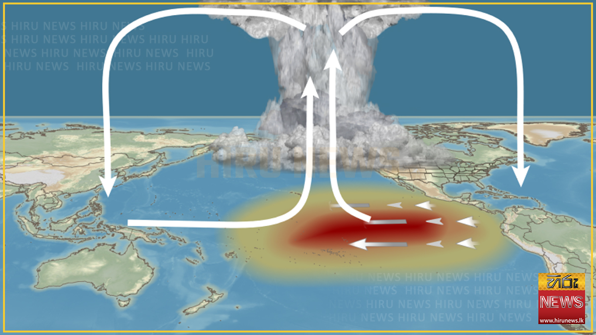
El Niño is a periodic warming of water in the central and eastern equatorial Pacific Ocean that can affect global weather patterns for months.
There have been 27 other El Niños since 1950, with one happening on average every three to four years.
The last one happened from summer 2023 into early spring 2024.
Record early June warmth
El Niños typically develop in spring, but this one pivoted rapidly.
But just over two months later, we're already in an El Niño.
In fact, ocean temperatures in the El Niño region are at record warm early June levels since at least 1982, according to Climate Central and NOAA data.
More strengthening ahead
This burgeoning El Niño will likely continue to intensify into a strong event, according to the CPC.
In fact, NOAA calculated a 63% chance it could eventually strengthen to a super El Niño, a term some meteorologists use to describe those with temperatures at least 2 degrees Celsius above average. That super El Niño could arrive as soon as late summer or early fall.
These super El Niños are more rare.
There have been only five since 1950, the last occurring 11 years ago from 2015-16. They also occured in 1997-98, 1991-92, 1982-83 and 1972-73. Super El Niños have also been documented in 1888-89 and 1877-78.
One for the record books?
Some computer forecast models suggest this El Niño could become one of the most intense on record.
For instance, the European model ensembles have trended warmer in their El Niño forecasts since spring.
As you can see in the animation below, a number of the ensemble forecasts are for the El Niño to top out at least 2.5 degrees above average by autumn or early winter, placing it in record territory.
Other models top it out either as strong (at least 1.5 degrees above average) or super, but not necessarily record breaking.
You can see this tongue of anomalously warm water forecast by the European model in the map below, stretching from the coast of South America to the central Pacific Ocean near the equator.
Another reason boosting confidence in this intense El Niño are surges of westerly winds near the equator in the western Pacific called westerly wind bursts.
"These periods of strong winds blowing west to east are pushing warm waters onto the equator and driving them eastward, contributing to rapid warming in the eastern Pacific," wrote Paul Roundy, a University of Albany professor and El Niño expert in an earlier email to weather.com.
Roundy noted an early April burst was one of the strongest in at least several decades.
What are the potential impacts?
First, some disclaimers.
El Niño (and its counterpart, La Niña) is only one influence on the global weather pattern. Also, every El Niño is different, much like every hurricane can have its own idiosyncrasies.
But, in general, the stronger the El Niño, the more likely it will impact global weather.
Here are some of those potential impacts.
Hurricane season
A stronger El Niño tends to produce more sinking air and stronger wind shear in parts of the Atlantic Basin, both hostile to hurricanes.
So, in general, most stronger El Niño Atlantic hurricane seasons are quieter than average. That's not always the case, as the 2023 season illustrated.
Meanwhile, eastern and central Pacific hurricane seasons are typically more active during strong El Niños.
Winter
In winter, the southern, or subtropical, branch of the jet stream usually is turbocharged in a stronger El Niño.
That means a wetter winter usually is the result across the southern tier of states from parts of California and the Desert Southwest to Florida and the Southeast. This could also mean more snow across these areas if the air is cold enough, as we illustrated in a previous deep dive.
Meanwhile, much of the northern U.S. typically has a milder and drier winter during a stronger El Niño, from the Northwest and northern Rockies to the Northern Plains and Midwest.
Global precipitation
El Niño's impacts typically extend around the globe. Those are highlighted on the map below.
For example, parts of Africa, India, Australia, the Philippines, Indonesia, the Caribbean and northern South America trend markedly drier during El Niño.
On the other hand, warm water and lighter trade winds typically sets the table for heavier rain in parts of Ecuador and Peru. Parts of eastern Africa, central Asia, Chile, Uruguay and Paraguay are also usually wetter than average during El Niño.
Global temperatures
One impact we're highly confident about is a spike in global temperatures during this El Niño. At the risk of oversimplifying, all this extra equatorial Pacific Ocean heat is released into the atmosphere, and all large swaths of drier conditions allow plentiful sunshine to heat the surface.
As the graph below nicely illustrates, the large majority of El Niños have triggered temperature spikes, including the last "non-super" El Niño in 2023.
The previous super El Niño crushed previous global temperature records in 2015 and 2016. Those two years remain among the top 10 warmest years for the planet, all of which have occurred since 2015.
Given last year was the planet's third warmest year, it seems like a slam dunk that new heat records will be set in 2026, possibly again in 2027.
From a climate change angle, this is worrisome.
A December 2025 study found super El Niño events can drive sudden "climate regime shifts" in both temperatures and precipitation, and that this effect could be increasing in a warming world.
-Yahoo News
It's here
The much anticipated El Niño conditions have developed as of early June, according to a monthly discussion published Thursday by NOAA's Climate Prediction Center.
Waters in a zone of the eastern and central Pacific Ocean near the equator have warmed to more than 0.5 degrees Celsius above average. This, plus the circulation of winds and distribution of showers and storms over that area now "reflect the onset of El Niño conditions," according to the CPC.
El Niño is a periodic warming of water in the central and eastern equatorial Pacific Ocean that can affect global weather patterns for months.
There have been 27 other El Niños since 1950, with one happening on average every three to four years.
The last one happened from summer 2023 into early spring 2024.
Record early June warmth
El Niños typically develop in spring, but this one pivoted rapidly.
But just over two months later, we're already in an El Niño.
In fact, ocean temperatures in the El Niño region are at record warm early June levels since at least 1982, according to Climate Central and NOAA data.
More strengthening ahead
This burgeoning El Niño will likely continue to intensify into a strong event, according to the CPC.
In fact, NOAA calculated a 63% chance it could eventually strengthen to a super El Niño, a term some meteorologists use to describe those with temperatures at least 2 degrees Celsius above average. That super El Niño could arrive as soon as late summer or early fall.
These super El Niños are more rare.
There have been only five since 1950, the last occurring 11 years ago from 2015-16. They also occured in 1997-98, 1991-92, 1982-83 and 1972-73. Super El Niños have also been documented in 1888-89 and 1877-78.
One for the record books?
Some computer forecast models suggest this El Niño could become one of the most intense on record.
For instance, the European model ensembles have trended warmer in their El Niño forecasts since spring.
As you can see in the animation below, a number of the ensemble forecasts are for the El Niño to top out at least 2.5 degrees above average by autumn or early winter, placing it in record territory.
Other models top it out either as strong (at least 1.5 degrees above average) or super, but not necessarily record breaking.
You can see this tongue of anomalously warm water forecast by the European model in the map below, stretching from the coast of South America to the central Pacific Ocean near the equator.
Another reason boosting confidence in this intense El Niño are surges of westerly winds near the equator in the western Pacific called westerly wind bursts.
"These periods of strong winds blowing west to east are pushing warm waters onto the equator and driving them eastward, contributing to rapid warming in the eastern Pacific," wrote Paul Roundy, a University of Albany professor and El Niño expert in an earlier email to weather.com.
Roundy noted an early April burst was one of the strongest in at least several decades.
What are the potential impacts?
First, some disclaimers.
El Niño (and its counterpart, La Niña) is only one influence on the global weather pattern. Also, every El Niño is different, much like every hurricane can have its own idiosyncrasies.
But, in general, the stronger the El Niño, the more likely it will impact global weather.
Here are some of those potential impacts.
Hurricane season
A stronger El Niño tends to produce more sinking air and stronger wind shear in parts of the Atlantic Basin, both hostile to hurricanes.
So, in general, most stronger El Niño Atlantic hurricane seasons are quieter than average. That's not always the case, as the 2023 season illustrated.
Meanwhile, eastern and central Pacific hurricane seasons are typically more active during strong El Niños.
Winter
In winter, the southern, or subtropical, branch of the jet stream usually is turbocharged in a stronger El Niño.
That means a wetter winter usually is the result across the southern tier of states from parts of California and the Desert Southwest to Florida and the Southeast. This could also mean more snow across these areas if the air is cold enough, as we illustrated in a previous deep dive.
Meanwhile, much of the northern U.S. typically has a milder and drier winter during a stronger El Niño, from the Northwest and northern Rockies to the Northern Plains and Midwest.
Global precipitation
El Niño's impacts typically extend around the globe. Those are highlighted on the map below.
For example, parts of Africa, India, Australia, the Philippines, Indonesia, the Caribbean and northern South America trend markedly drier during El Niño.
On the other hand, warm water and lighter trade winds typically sets the table for heavier rain in parts of Ecuador and Peru. Parts of eastern Africa, central Asia, Chile, Uruguay and Paraguay are also usually wetter than average during El Niño.
Global temperatures
One impact we're highly confident about is a spike in global temperatures during this El Niño. At the risk of oversimplifying, all this extra equatorial Pacific Ocean heat is released into the atmosphere, and all large swaths of drier conditions allow plentiful sunshine to heat the surface.
As the graph below nicely illustrates, the large majority of El Niños have triggered temperature spikes, including the last "non-super" El Niño in 2023.
The previous super El Niño crushed previous global temperature records in 2015 and 2016. Those two years remain among the top 10 warmest years for the planet, all of which have occurred since 2015.
Given last year was the planet's third warmest year, it seems like a slam dunk that new heat records will be set in 2026, possibly again in 2027.
From a climate change angle, this is worrisome.
A December 2025 study found super El Niño events can drive sudden "climate regime shifts" in both temperatures and precipitation, and that this effect could be increasing in a warming world.
-Yahoo News