



Share Post


Update: So far, NO major damages to Sri Lanka due to Cyclone Burevi. Very heavy rains & very strong winds forecast for next few hours.
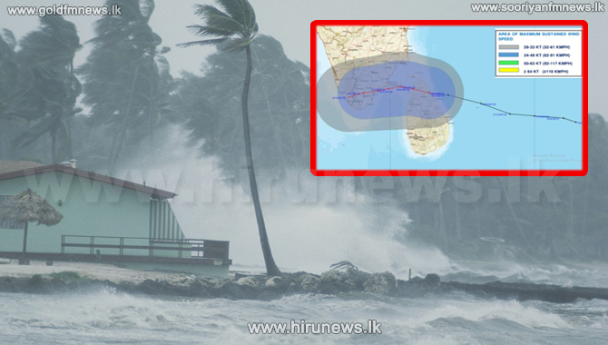
The center of the cyclonic storm ‘BUREVI’ has crossed north-eastern coast of Sri Lanka between Kuchchaveli and Thiriyayi between 10.30 - 11.30 pm 02 December.
This Cyclonic storm with a wind speed of 70-80 kmph gusting up to 90 kmph is very likely to move weat-northwestwards, emerge into Gulf of Mannar by noon today. Hence the influence of the cyclonic storm is expected to be gradually reduced during next few hours.
Showers or thundershowers will occur in the Northern, North-western and North-central provinces. Very heavy rainfall above 150 mm can be expected at some places.
Showers will occur at times in the Western and sabaragamuwa provinces and in Galle and Matara districts.
WEATHER FORECAST FOR SEA AREAS AROUND THE ISLAND DURING NEXT 24 HOURS - Issued at 05.30 a.m. on 03 December 2020
Naval and fishing communities are advised not to venture into the deep and shallow-sea areas off the coast extending from Colombo to Trincomalee via Mannar and Kankasanthureyi until tomorrow morning.
Fishermen are advised to be vigilant in other sea areas.
Condition of Rain:
Intermittent showers or thundershowers will occur in the deep and shallow sea areas extending from Puttalam to Trincomalee via Mannar and Kankasanthurai.Very heavy showers can be expected some places in the above sea areas. Showers will occur at times elsewhere.
Winds:
Winds will be westerly to south-westerly in the sea areas extending from Colombo to Trincomalee via Puttalam and Kankasanthureyi. wind speed will be (60-70) kmph and wind speed can increase up to 80kmph at times over these sea areas.
Winds will be south-easterly or variable in the other sea areas around the island and the wind speed will be (40-50) kmph and can increase up to 60 kmph at times.
State of Sea:
The sea areas extending from Colombo to Trincomalee via Puttalam and Kankasanthureyi can be very rough or high at times. The other sea areas can berough or very rough at times.
There is a possibility that near shore sea areas off the coast extending from Negombo to Kankasanthureyi via Puttalam may experience surges due to the effect of swell waves, having (2.0-3.0) m height.

The center of the cyclonic storm ‘BUREVI’ has crossed north-eastern coast of Sri Lanka between Kuchchaveli and Thiriyayi between 10.30 - 11.30 pm 02 December.
This Cyclonic storm with a wind speed of 70-80 kmph gusting up to 90 kmph is very likely to move weat-northwestwards, emerge into Gulf of Mannar by noon today. Hence the influence of the cyclonic storm is expected to be gradually reduced during next few hours.
Showers or thundershowers will occur in the Northern, North-western and North-central provinces. Very heavy rainfall above 150 mm can be expected at some places.
Showers will occur at times in the Western and sabaragamuwa provinces and in Galle and Matara districts.
WEATHER FORECAST FOR SEA AREAS AROUND THE ISLAND DURING NEXT 24 HOURS - Issued at 05.30 a.m. on 03 December 2020
Naval and fishing communities are advised not to venture into the deep and shallow-sea areas off the coast extending from Colombo to Trincomalee via Mannar and Kankasanthureyi until tomorrow morning.
Fishermen are advised to be vigilant in other sea areas.
Condition of Rain:
Intermittent showers or thundershowers will occur in the deep and shallow sea areas extending from Puttalam to Trincomalee via Mannar and Kankasanthurai.Very heavy showers can be expected some places in the above sea areas. Showers will occur at times elsewhere.
Winds:
Winds will be westerly to south-westerly in the sea areas extending from Colombo to Trincomalee via Puttalam and Kankasanthureyi. wind speed will be (60-70) kmph and wind speed can increase up to 80kmph at times over these sea areas.
Winds will be south-easterly or variable in the other sea areas around the island and the wind speed will be (40-50) kmph and can increase up to 60 kmph at times.
State of Sea:
The sea areas extending from Colombo to Trincomalee via Puttalam and Kankasanthureyi can be very rough or high at times. The other sea areas can berough or very rough at times.
There is a possibility that near shore sea areas off the coast extending from Negombo to Kankasanthureyi via Puttalam may experience surges due to the effect of swell waves, having (2.0-3.0) m height.
Latest News
Police fire shots at car after driver ignores orders to stop
Local
29 August 2026
GMOA warns of action against attempts to create divisions among doctors
Local
29 August 2026

Sri Lanka monitors Iranian tankers anchored near Exclusive Economic Zone
Local
29 August 2026
Only 9,699 dengue cases reported so far this month
Local
29 August 2026

Rough seas expected in several coastal areas
Local
29 August 2026

Neeraj Chopra ends 2026 season early due to ankle injury
Local
29 August 2026

Sevanagala Sugar Factory closed until further notice
Local
29 August 2026
Man missing after alleged crocodile attack found dead
Local
29 August 2026

184 foreign national rescued from Nepal floods
Local
29 August 2026
Nicolas Jackson joins Aston Villa in record deal
Local
29 August 2026